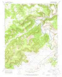
1972 Map of Sabinoso
USGS Topo · Published 1975About this map
The Canadian River and Mora River converge in this high-plains landscape of northeastern San Miguel County, carving deep canyons into the mesas. The small settlement of Sabinoso serves as a central point, anchored by the Santa Mission Ch and nearby cemeteries. The map reveals a remote ranching and subsistence economy where travel relied on routes like the Pack Trail and Deep Trail through the breaks. Named topographic features like Cerro del Miguel Antonio and La Botella indicate a landscape deeply tied to local family names and landmarks. Further south, the community of Sanchez is noted along with its own Cem, while Ancon sits near the river bend. The intricate network of canyons, including Cañon Largo and Cañon Sabinoso, illustrates the dramatic erosion patterns typical of this portion of the Canadian River basin.
Find a feature on this map
26 named features on this map. Tap any name to fly to it.
Don’t see what you’re looking for? This feature index may not catch every label — zoom into the map to look around manually.
Map Details
Editions of this 1972 Sabinoso Map
This is the sole edition of this map. No revisions or reprints were ever made.
Other maps of this area

1892 · Watrous
USGS Topo · 1:125,000

1894 · Watrous
USGS Topo · 1:125,000

1954 · Santa Fe
USGS Topo · 1:250,000

1958 · Santa Fe
USGS Topo · 1:250,000

1964 · Canon Ancho
USGS Topo · 1:24,000

1971 · Alamito
USGS Topo · 1:24,000

1971 · Canon Olguin
USGS Topo · 1:24,000

1971 · Canon Encierro
USGS Topo · 1:24,000

1972 · Arroyo Alamocito
USGS Topo · 1:24,000
1972 · Maes
USGS Topo · 1:24,000