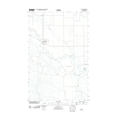
2011 Map of Saco
USGS Topo · Published 2011About this map
Saco serves as the primary hub in this portion of Phillips County, defined by the winding course of Beaver Creek and a complex network of irrigation infrastructure. The town center is anchored by the Saco Post Office and the Phillips Co Vol Fire Company Saco Sta, while the northern hills are home to Grandview Cemetery. The landscape reflects a ranching and agricultural economy, with significant man-made water features such as the Nelson South Canal and Nelson South Number 9 Canal branching across the plains to support the local homesteads.
Find a feature on this map
20 named features on this map. Tap any name to fly to it.
Don’t see what you’re looking for? This feature index may not catch every label — zoom into the map to look around manually.
Map Details
Editions of this 2011 Saco Map
This is the sole edition of this map. No revisions or reprints were ever made.
Other maps of this area

1905 · Saco Special
USGS Topo · 1:62,500

1906 · Hinsdale Special Map
USGS Topo · 1:62,500

1954 · Glasgow
USGS Topo · 1:250,000

1957 · Glasgow
USGS Topo · 1:250,000

1958 · Glasgow
USGS Topo · 1:250,000

1984 · Cole
USGS Topo · 1:24,000

1984 · Bjornberg Bridge
USGS Topo · 1:24,000
1984 · Robinson Ranch
USGS Topo · 1:24,000

1984 · Double S Hill
USGS Topo · 1:24,000

1984 · Ashford Coulee
USGS Topo · 1:24,000