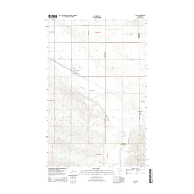
2014 Map of Saco
USGS Topo · Published 2014About this map
The town of Saco serves as a central hub on the northern Montana plains, defined by the industrial corridor of the BNSF Railway and Us-2. This landscape is heavily shaped by complex irrigation infrastructure, notably the Nelson S Canal and the Nelson S Number 9 Canal, which divert water across the prairie to support agriculture. To the southeast, the small settlement of Beaverton sits near the Beaver Creek Bridge, where the terrain begins to transition into the more elevated Larb Hills. The map provides a detailed view of the regional water system, including the meandering paths of Beaver Creek, Larb Creek, and Second Creek. For those researching local family history, the Grandview Cemetery is clearly marked north of the main settlement along Highway 243, providing a specific point of interest for genealogical study.
Find a feature on this map
31 named features on this map. Tap any name to fly to it.
Don’t see what you’re looking for? This feature index may not catch every label — zoom into the map to look around manually.
Map Details
Editions of this 2014 Saco Map
This is the sole edition of this map. No revisions or reprints were ever made.
Other maps of this area

1905 · Saco Special
USGS Topo · 1:62,500

1906 · Hinsdale Special Map
USGS Topo · 1:62,500

1954 · Glasgow
USGS Topo · 1:250,000

1957 · Glasgow
USGS Topo · 1:250,000

1958 · Glasgow
USGS Topo · 1:250,000

1984 · Cole
USGS Topo · 1:24,000

1984 · Bjornberg Bridge
USGS Topo · 1:24,000
1984 · Robinson Ranch
USGS Topo · 1:24,000

1984 · Double S Hill
USGS Topo · 1:24,000

1984 · Ashford Coulee
USGS Topo · 1:24,000