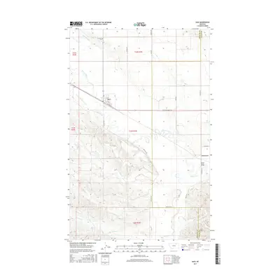
2017 Map of Saco
USGS Topo · Published 2017About this map
Saco serves as the central hub of this prairie landscape, where the town layout is defined by streets like 1st Ave and Taylor St near the intersection of the Lewis and Clark Trl. The geography is shaped significantly by early 20th-century irrigation efforts, visible through the Nelson S Canal and Nelson Number 9 Canal that cut across the northern sections. These man-made waterways contrast with the wandering path of Beaver Creek, which meanders eastward toward the smaller settlement of Beaverton.
Find a feature on this map
29 named features on this map. Tap any name to fly to it.
Don’t see what you’re looking for? This feature index may not catch every label — zoom into the map to look around manually.
Map Details
Editions of this 2017 Saco Map
This is the sole edition of this map. No revisions or reprints were ever made.
Other maps of this area

1905 · Saco Special
USGS Topo · 1:62,500

1906 · Hinsdale Special Map
USGS Topo · 1:62,500

1954 · Glasgow
USGS Topo · 1:250,000

1957 · Glasgow
USGS Topo · 1:250,000

1958 · Glasgow
USGS Topo · 1:250,000

1984 · Cole
USGS Topo · 1:24,000

1984 · Bjornberg Bridge
USGS Topo · 1:24,000
1984 · Robinson Ranch
USGS Topo · 1:24,000

1984 · Double S Hill
USGS Topo · 1:24,000

1984 · Ashford Coulee
USGS Topo · 1:24,000