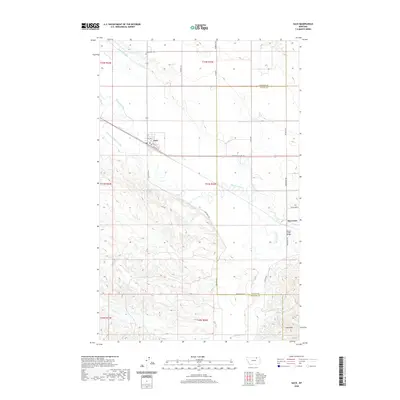
2020 Map of Saco
USGS Topo · Published 2020About this map
Saco serves as the primary hub of this landscape, where local streets like Vagg St and Taylor St meet the corridor of the Lewis and Clark Trl. The area's agricultural reliance is clearly etched into the terrain through an extensive irrigation network, including the Nelson S Canal and the Nelson S Number 9 Canal. To the north, the Grandview Cem sits atop the high ground, while the southern reaches are defined by the rising elevations of the Larb Hills. The intricate hydrology of the region is dominated by the winding path of Beaver Creek, which is crossed by the Beaver Creek Bridge near the settlement of Beaverton. This layout reflects a classic Big Sky ranching and farming community where the management of water from sources like First Cr and Second Cr is essential to life on the plains.
Find a feature on this map
33 named features on this map. Tap any name to fly to it.
Don’t see what you’re looking for? This feature index may not catch every label — zoom into the map to look around manually.
Map Details
Editions of this 2020 Saco Map
This is the sole edition of this map. No revisions or reprints were ever made.
Other maps of this area

1905 · Saco Special
USGS Topo · 1:62,500

1906 · Hinsdale Special Map
USGS Topo · 1:62,500

1954 · Glasgow
USGS Topo · 1:250,000

1957 · Glasgow
USGS Topo · 1:250,000

1958 · Glasgow
USGS Topo · 1:250,000

1984 · Cole
USGS Topo · 1:24,000

1984 · Bjornberg Bridge
USGS Topo · 1:24,000
1984 · Robinson Ranch
USGS Topo · 1:24,000

1984 · Double S Hill
USGS Topo · 1:24,000

1984 · Ashford Coulee
USGS Topo · 1:24,000