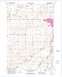
1991 Map of Saco
USGS Topo · Published 1995About this map
Straight River and Turtle Cr define the southeastern drainage of this Steele County landscape, where the prairie has been systematically organized into the townships of Deerfield, Meriden, and Somerset. A network of agricultural drainage channels, including Judicial Ditch No 1 and County Ditch No 20, illustrates the mid-century effort to manage the local water table for farming. The map documents a scattered rural infrastructure of one-room schoolhouses like School No 2148 and Crane Creek Sch, alongside family and community burial grounds such as Mueller Cem and Bohemian Cem. Conservation efforts are visible in the Swan Lake State Wildlife Management Area, while the expansion of Owatonna is captured through modern infrastructure updates near Interchange 40 and the Owatonna Airport.
Find a feature on this map
32 named features on this map. Tap any name to fly to it.
Don’t see what you’re looking for? This feature index may not catch every label — zoom into the map to look around manually.
Map Details
Editions of this 1991 Saco Map
This is the sole edition of this map. No revisions or reprints were ever made.
Other maps of this area

1953 · Saint Paul
USGS Topo · 1:250,000

1954 · Mason City
USGS Topo · 1:250,000

1957 · Mason City
USGS Topo · 1:250,000

1958 · Mason City
USGS Topo · 1:250,000

1959 · Saint Paul
USGS Topo · 1:250,000

1962 · Medford East
USGS Topo · 1:24,000

1962 · Morristown
USGS Topo · 1:24,000

1962 · Owatonna
USGS Topo · 1:24,000

1962 · Saco
USGS Topo · 1:24,000

1962 · Meriden
USGS Topo · 1:24,000