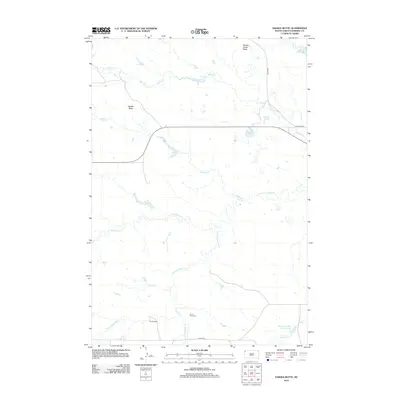
2012 Map of Saddle Butte
USGS Topo · Published 2012About this map
S Fork Grand River and the Little Grand River converge in this section of Harding County, defining a landscape of prairie drainages and isolated high points. The terrain is marked by prominent landforms such as Saddle Butte and Brush Creek Butte, which serve as natural landmarks across the open range. Local ranching history is evidenced by the presence of S Price Ranch, while the rural community is anchored by the Grand River Cem situated near the riverbanks. Human intervention in the arid environment is visible through the Gilbert Number One Reservoir and the small waters of Lake Gardner. A network of gravel routes, including Lewton Rd, Clanton Rd, and Gilbert Rd, provides the primary access through these expansive grazing lands.
Find a feature on this map
17 named features on this map. Tap any name to fly to it.
Don’t see what you’re looking for? This feature index may not catch every label — zoom into the map to look around manually.
Map Details
Editions of this 2012 Saddle Butte Map
This is the sole edition of this map. No revisions or reprints were ever made.
Other maps of this area

1935 · Harding
USGS Topo · 1:125,000

1935 · Buffalo
USGS Topo · 1:125,000

1954 · Lemmon
USGS Topo · 1:250,000

1957 · Lemmon
USGS Topo · 1:250,000

1971 · Buffalo
USGS Topo · 1:24,000
1971 · Lahti Butte
USGS Topo · 1:24,000

1971 · McKenzie Butte
USGS Topo · 1:24,000

1971 · Saddle Butte
USGS Topo · 1:24,000

1973 · Bog Creek
USGS Topo · 1:24,000

1973 · Gallup Creek
USGS Topo · 1:24,000