1989 Map of Saffordville
USGS Topo · Published 1990About this map
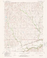
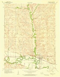
Saffordville and the nearby siding of Ellinor sit along the northern banks of the Cottonwood River in this detailed survey of Chase County. The landscape is defined by the winding drainages of Buckeye Creek, Peyton Creek, and Stout Creek, which carve through the Flint Hills terrain. To the north, the small settlement of Toledo remains a distinct marker of early Kansas habitation near East Buckeye Creek. Historical researchers will find the location of Hillside Cem and various local landmarks such as a Radio Tower and a Gravel Pit. The map captures the infrastructure of the late 1980s, including a prominent Pipeline traversing the rural townships of Strong, Toledo, and Falls. Small water bodies like Kahola dot the northern reaches, while Bull Creek joins the river system near the rail lines that historically served these prairie communities.
Find a feature on this map
19 named features on this map. Tap any name to fly to it.
Don’t see what you’re looking for? This feature index may not catch every label — zoom into the map to look around manually.
Map Details
Editions of this 1989 Saffordville Map
This is the sole edition of this map. No revisions or reprints were ever made.
Other maps of this area

1885 · Eskridge
USGS Topo · 1:125,000

1888 · Emporia
USGS Topo · 1:125,000

1889 · Parkerville
USGS Topo · 1:125,000

1889 · Eskridge
USGS Topo · 1:125,000

1894 · Emporia
USGS Topo · 1:125,000

1894 · Eskridge
USGS Topo · 1:125,000

1894 · Parkerville
USGS Topo · 1:125,000

1898 · Cottonwood Falls
USGS Topo · 1:125,000

1955 · Hutchinson
USGS Topo · 1:250,000
1957 · Strong City
USGS Topo · 1:24,000