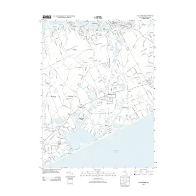
2013 Map of Sag Harbor
USGS Topo · Published 2013About this map
Sag Harbor and the surrounding coastal hamlets of the South Fork define this landscape of interconnected coves and ponds. The village of Bridgehampton serves as a central hub, where the Beebe Windmill stands as a landmark of the area's agricultural past. Moving south toward the Atlantic, the terrain transitions into the maritime settlements of Sagaponack, Mecox, and Water Mill. The map reveals a dense network of family and historical burial sites, including the Saint David African Methodist Episcopal Zion Cemetery and the Hay Ground Cemetery, which are essential for genealogical research in Suffolk County. To the north, the intricate shorelines of Noyack Creek and Upper Sag Harbor Cove showcase the region's deep ties to the water. The interior is marked by numerous kettle ponds such as Long Pond and Crooked Pond, illustrating the glacial topography unique to this part of Long Island.
Find a feature on this map
107 named features on this map. Tap any name to fly to it.
Don’t see what you’re looking for? This feature index may not catch every label — zoom into the map to look around manually.
Map Details
Editions of this 2013 Sag Harbor Map
This is the sole edition of this map. No revisions or reprints were ever made.
Other maps of this area

1903 · Sag Harbor
USGS Topo · 1:62,500

1903 · Gardiners Island
USGS Topo · 1:62,500

1904 · Sag Harbor
USGS Topo · 1:62,500

1904 · Shelter Island
USGS Topo · 1:62,500

1904 · Easthampton
USGS Topo · 1:62,500

1904 · Gardiners Island
USGS Topo · 1:62,500

1921 · Gardiners Island
USGS Topo · 1:62,500

1921 · Easthampton
USGS Topo · 1:62,500

1944 · Gardiners Island West
USGS Topo · 1:24,000

1946 · Sag Harbor
USGS Topo · 1:24,000