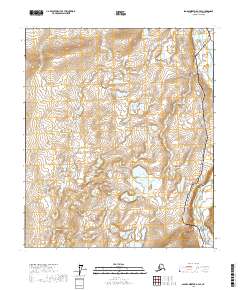
2017 Map of Sagavanirktok A-4 SE
USGS Topo · Published 2017About this map
The Sagavanirktok River meanders through the eastern edge of this Arctic landscape, defining the topography of the North Slope. This 2017 survey documents a critical corridor for industrial infrastructure, dominated by the path of the Alaska Pipeline. The line runs roughly north-south, tracing the higher ground above the river's floodplain. The surrounding terrain is characterized by a dense network of wetlands and small water bodies, typical of the permafrost-influenced regions above the Arctic Circle. The map provides a precise look at the township and range boundaries including t4s r13e, t4s r14e, t5s r13e, and t5s r14e, which organize this sparsely populated but economically vital territory.
Find a feature on this map
6 named features on this map. Tap any name to fly to it.
Don’t see what you’re looking for? This feature index may not catch every label — zoom into the map to look around manually.
Map Details
Editions of this 2017 Sagavanirktok A-4 SE Map
This is the sole edition of this map. No revisions or reprints were ever made.
Other maps of this area

1951 · Sagavanirktok D-5
USGS Topo · 1:250,000

1951 · Brooks
USGS Topo · 1:250,000

1956 · Philip Smith Mountains
USGS Topo · 1:250,000

1956 · Sagavanirktok
USGS Topo · 1:250,000

1958 · Sagavanirktok
USGS Topo · 1:250,000

1964 · Philip Smith Mountains
USGS Topo · 1:250,000

1964 · Sagavanirktok
USGS Topo · 1:250,000
1971 · Philip Smith Mountains D-3
USGS Topo · 1:63,360
1971 · Sagavanirktok A-3
USGS Topo · 1:63,360
1971 · Sagavanirktok A-4
USGS Topo · 1:63,360