
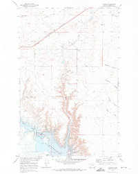
1970 Map of Sagebrush Coulee
USGS Topo · Published 1973About this map
Sagebrush Coulee and the surrounding high plains of Liberty County appear here as a landscape defined by water management and natural drainages. Published as part of a Department of the Interior program for the development of the Missouri River Basin, the topography reflects an era of agricultural engineering. Man-made features like the Aqueduct and the Landing Strip point to the practical infrastructure of the 1970s, while numerous reservoirs such as Walden Reservoir and Patts Reservoir illustrate the critical role of water storage in this semi-arid region. The intricate network of coulees, including Beebe Coulee, Fey Coulee, and Twelvemile Coulee, provides a glimpse into the natural erosion patterns and drainage systems that dictate the use of this Montana terrain. Researchers can find subtle evidence of land division and land-use priorities through the placement of these water resources and transportation markers.
Find a feature on this map
14 named features on this map. Tap any name to fly to it.
Don’t see what you’re looking for? This feature index may not catch every label — zoom into the map to look around manually.
Map Details
Editions of this 1970 Sagebrush Coulee Map
This is the sole edition of this map. No revisions or reprints were ever made.
Other maps of this area

1919 · Alma
USGS Topo · 1:125,000

1954 · Shelby
USGS Topo · 1:250,000

1958 · Shelby
USGS Topo · 1:250,000

1962 · Tiber
USGS Topo · 1:24,000

1962 · North Lothair School
USGS Topo · 1:24,000

1963 · Chester
USGS Topo · 1:24,000

1970 · Circle Bridge
USGS Topo · 1:24,000

1970 · Poverty Coulee
USGS Topo · 1:24,000

1970 · Lothair SW
USGS Topo · 1:24,000
1970 · Lothair
USGS Topo · 1:24,000