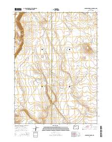
2014 Map of Sagebrush Knoll
USGS Topo · Published 2014About this map
Sagebrush Knoll and the high desert terrain of the Oregon outback define this survey, where the border of Lake County and Harney County runs through a landscape of ridges and draws. The map illustrates a remote network of range roads and tracks essential for livestock management and land access, including Clark Cow Cp and the intersecting routes of E Sherlock and W Sherlock. The topographical detail captures the descent from Flint Ridge into the surrounding flats, revealing the specialized nomenclature of the region's geography through names like Badger Draw and the descriptively titled Nasty Flat Rd. This is a landscape where water and elevation dictate movement, as evidenced by the placement of Corn Lake Rd and other connectors that link these high-altitude features across the high desert floor.
Find a feature on this map
15 named features on this map. Tap any name to fly to it.
Don’t see what you’re looking for? This feature index may not catch every label — zoom into the map to look around manually.
Map Details
Editions of this 2014 Sagebrush Knoll Map
This is the sole edition of this map. No revisions or reprints were ever made.
Other maps of this area

1955 · Klamath Falls
USGS Topo · 1:250,000

1955 · Adel
USGS Topo · 1:250,000

1957 · Adel
USGS Topo · 1:250,000

1958 · Klamath Falls
USGS Topo · 1:250,000

1958 · Adel
USGS Topo · 1:250,000

1962 · Adel
USGS Topo · 1:250,000

1966 · Rabbit Hills NE
USGS Topo · 1:24,000

1966 · Rabbit Hills NW
USGS Topo · 1:24,000

1968 · Commodore Ridge
USGS Topo · 1:24,000

1974 · Lake Abert
USGS Topo · 1:100,000