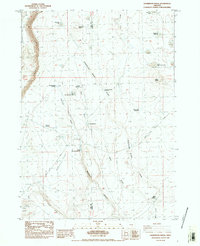
1984 Map of Sagebrush Knoll
USGS Topo · Published 1984About this map
Abert Rim defines the western edge of this high desert landscape, dropping sharply toward the basin floor. The terrain is characterized by a series of seasonal catchments and waterholes essential for livestock management in this arid stretch of Lake County. Central to the map's activity is the Lynch Cow Camp Corral, which along with Sherlock Waterhole and Hub Reservoir, illustrates the infrastructure of the local cattle ranching economy during the early 1980s. A network of draws, including Dent Draw and Sagebrush Draw, channel intermittent runoff from features like Sagebrush Knoll and Eagle Butte. The presence of the Lake Co Harney Co boundary and the remote Nasty Flat Road highlight the isolation and specialized land use of this region before modern developments.
Find a feature on this map
27 named features on this map. Tap any name to fly to it.
Don’t see what you’re looking for? This feature index may not catch every label — zoom into the map to look around manually.
Map Details
Editions of this 1984 Sagebrush Knoll Map
This is the sole edition of this map. No revisions or reprints were ever made.
Other maps of this area

1955 · Klamath Falls
USGS Topo · 1:250,000

1955 · Adel
USGS Topo · 1:250,000

1957 · Adel
USGS Topo · 1:250,000

1958 · Klamath Falls
USGS Topo · 1:250,000

1958 · Adel
USGS Topo · 1:250,000

1962 · Adel
USGS Topo · 1:250,000

1966 · Rabbit Hills NE
USGS Topo · 1:24,000

1966 · Rabbit Hills NW
USGS Topo · 1:24,000

1968 · Commodore Ridge
USGS Topo · 1:24,000

1974 · Lake Abert
USGS Topo · 1:100,000