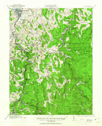
1912 Map of Sago
USGS Topo · Published 1962About this map
The Buckhannon area and the headwaters of the Tygart Valley River emerge in this 1912 survey, revealing a landscape defined by small settlements and rural education. The industrial footprint of the era is evident through the Lumber RR and the B & O RR Pickens Br, which facilitated timber and resource extraction across Upshur and Randolph counties. Community life is anchored by numerous small schools such as Red Knot School and Water Camp School, alongside local landmarks like Mt Zion Church. Local commerce is reflected in the postal and milling operations at Hampton Ivanhoe P.O. and Beans Mill. This documentation of the southern reaches of the Buckhannon River captures the region before extensive modernization, preserving the locations of family-named settlements like Tallmansville, Alexander, and Queens.
Find a feature on this map
113 named features on this map. Tap any name to fly to it.
Don’t see what you’re looking for? This feature index may not catch every label — zoom into the map to look around manually.
Map Details
Editions of this 1912 Sago Map
4 editions found

Other maps of this area

1886 · St. George
USGS Topo · 1:125,000

1889 · Beverly
USGS Topo · 1:125,000

1891 · St. George
USGS Topo · 1:125,000

1892 · Beverly
USGS Topo · 1:125,000

1893 · Buckhannon
USGS Topo · 1:125,000

1896 · Buckhannon
USGS Topo · 1:125,000

1897 · Buckhannon
USGS Topo · 1:125,000

1904 · Philippi
USGS Topo · 1:62,500

1904 · Weston
USGS Topo · 1:62,500

1907 · Belington
USGS Topo · 1:62,500