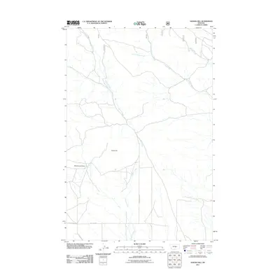
2011 Map of Sahara Hill
USGS Topo · Published 2011About this map
Sahara Hill rises above a high prairie landscape in Musselshell County, defined by a network of drainage systems and isolated ranch roads. The map highlights the headwaters and winding paths of several watercourses, most notably the central flow of Cameron Creek and the bifurcated North Fork Pole Creek and South Fork Pole Creek which converge to form Pole Creek in the northeast. This 2011 survey captures the area's rural transportation network, anchored by Cameron Creek Rd and the intersections of Ray Creek Rd near Stonehouse Canyon. The land use pattern is distinctly focused on the natural topography of the eastern Montana plains, where the names of small draws like Minerva Creek and Ray Creek signify the essential water sources that have historically shaped local land holdings and grazing territories.
Find a feature on this map
12 named features on this map. Tap any name to fly to it.
Don’t see what you’re looking for? This feature index may not catch every label — zoom into the map to look around manually.
Map Details
Editions of this 2011 Sahara Hill Map
This is the sole edition of this map. No revisions or reprints were ever made.
Other maps of this area

1889 · Big Snowy Mountain
USGS Topo · 1:250,000

1893 · Big Snowy Mountain
USGS Topo · 1:250,000

1954 · Roundup
USGS Topo · 1:250,000

1958 · Roundup
USGS Topo · 1:250,000

1970 · South Bench
USGS Topo · 1:24,000
1970 · Alaska Bench
USGS Topo · 1:24,000

1986 · Devils Hole Lake
USGS Topo · 1:24,000

1986 · Patterson Canyon
USGS Topo · 1:24,000

1986 · Emory School
USGS Topo · 1:24,000
1986 · Sahara Hill
USGS Topo · 1:24,000