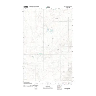
2011 Map of Saint Andrews
USGS Topo · Published 2011About this map
The settlement of Saint Andrews centers this Douglas County landscape, where the high plateau is marked by a network of seasonal water bodies and local irrigation infrastructure. Local family names and community history are preserved in the locations of the Danish Cemetery and Saint Andrews Cemetery, which sit among the dryland farming blocks. The terrain is characterized by depressions that hold water, such as Haynes Lake, Stallard Lake, and Bennett Lake, supplemented by man-made structures like the Jenkins-Webley Dam and Jorgensen Dam. In the southeastern corner, the elevation rises toward Gilbert Butte, providing a distinct landmark against the grid of section roads that define the region's agricultural layout. This map reflects the enduring rural character of the Big Bend country, where the intersection of St Andrews North Rd NE and St Andrews West Rd NE serves as a primary geographic hub.
Find a feature on this map
26 named features on this map. Tap any name to fly to it.
Don’t see what you’re looking for? This feature index may not catch every label — zoom into the map to look around manually.
Map Details
Editions of this 2011 Saint Andrews Map
This is the sole edition of this map. No revisions or reprints were ever made.
Other maps of this area

1930 · Grand Coulee Sheet 3
USGS Topo · 1:31,680

1953 · Ritzville
USGS Topo · 1:250,000

1959 · Ritzville
USGS Topo · 1:250,000

1965 · Ritzville
USGS Topo · 1:250,000

1965 · Jameson Lake SE
USGS Topo · 1:24,000

1965 · St. Andrews
USGS Topo · 1:24,000

1965 · Jameson Lake East
USGS Topo · 1:24,000

1965 · Mold
USGS Topo · 1:24,000
1965 · Park Lake
USGS Topo · 1:24,000

1965 · Coulee City
USGS Topo · 1:24,000