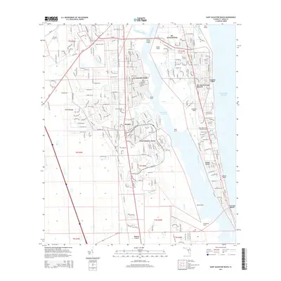
2015 Map of Saint Augustine Beach
USGS Topo · Published 2015About this map
St. Augustine and its southern coastal suburbs are defined by the intricate waterways separating the mainland from Anastasia Island. This survey captures the residential expansion of the early 21st century, showing established neighborhoods like St. Augustine South and Saint Augustine Shores situated along the western banks of the Matanzas River. The map highlights the critical role of the Intracoastal Waterway in local geography, with the Mickler Oconnel Bridge providing essential connectivity to the beach communities. Historic land divisions are visible through township and range boundaries like t7s r29e, while local heritage is preserved at sites such as San Lorenzo Cem and the location of Fort Peyton. Along the coast, the transition from St. Augustine Beach south to Butler Beach and Crescent Beach illustrates the dense development between the river and the Atlantic Ocean.
Find a feature on this map
41 named features on this map. Tap any name to fly to it.
Don’t see what you’re looking for? This feature index may not catch every label — zoom into the map to look around manually.
Map Details
Editions of this 2015 Saint Augustine Beach Map
This is the sole edition of this map. No revisions or reprints were ever made.
Other maps of this area

1927 · Matanzas
USGS Topo · 1:48,000

1937 · Bakersville
USGS Topo · 1:24,000

1937 · Elkton
USGS Topo · 1:24,000

1937 · Crescent Beach
USGS Topo · 1:24,000

1937 · Dinner Island
USGS Topo · 1:48,000

1937 · St. Augustine
USGS Topo · 1:24,000

1943 · St. Augustine
USGS Topo · 1:62,500

1943 · Dinner Island
USGS Topo · 1:62,500

1943 · Matanzas
USGS Topo · 1:62,500

1944 · Dinner Island
USGS Topo · 1:62,500
Featured Places
- Saint Augustine, FL
- Saint Augustine Beach, FL
- Saint Augustine South, FL
- Saint Augustine Shores, FL
- Butler Beach, FL