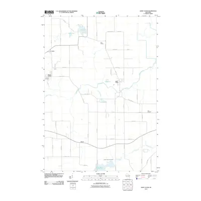
2010 Map of Saint Cloud
USGS Topo · Published 2010About this map
The Sheboygan River winds through the northern landscape of this Sheboygan County area, anchoring the villages of Saint Cloud, Mount Calvary, and Calvary. The terrain is defined by a series of glacial water bodies, including Wolf Lake, Giltners Lake, and Mischos Pond, which are linked by a network of drainage ways like Feldners Creek. Further south, the map details the controlled waters of the Mullet River, featuring the Mullet Creek G12.473 Dam and the Mullet Marsh 15 Reservoir. This 2010 survey illustrates a primarily rural dairy-land character, where farm roads like Triple T Rd and Log Tavern Rd connect small settlements. Genealogists will find value in the clearly marked burial grounds, such as Saint Joseph Cemetery, Holy Cross Cemetery, and the West Greenbush Cemetery located on the eastern edge of the quadrangle near the settlement of Banner.
Find a feature on this map
52 named features on this map. Tap any name to fly to it.
Don’t see what you’re looking for? This feature index may not catch every label — zoom into the map to look around manually.
Map Details
Editions of this 2010 Saint Cloud Map
This is the sole edition of this map. No revisions or reprints were ever made.
Other maps of this area

1910 · Fond du Lac
USGS Topo · 1:62,500

1954 · Kiel
USGS Topo · 1:62,500

1955 · Campbellsport
USGS Topo · 1:62,500

1955 · Kewaskum
USGS Topo · 1:62,500

1955 · Fond Du Lac
USGS Topo · 1:62,500

1957 · Madison
USGS Topo · 1:250,000

1960 · Madison
USGS Topo · 1:250,000

1974 · St. Cloud
USGS Topo · 1:24,000
1974 · Kiel
USGS Topo · 1:24,000
1974 · Elkhart Lake
USGS Topo · 1:24,000