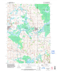
1992 Map of Saint Cloud
USGS Topo · Published 1996About this map
St Cloud and the surrounding townships of Marshfield and Forest anchor this 1990s landscape, where glacial legacy and agricultural industry converge. The terrain is defined by extensive wetlands, notably the Sheboygan Marsh and the Mullet Creek system, much of which is protected within the Saint Cloud State Wildlife Areas. This abundance of surface water and marshland is punctuated by numerous Gravel Pits, signaling the importance of aggregate mining to the local economy.
Find a feature on this map
52 named features on this map. Tap any name to fly to it.
Don’t see what you’re looking for? This feature index may not catch every label — zoom into the map to look around manually.
Map Details
Editions of this 1992 Saint Cloud Map
This is the sole edition of this map. No revisions or reprints were ever made.
Other maps of this area

1910 · Fond du Lac
USGS Topo · 1:62,500

1954 · Kiel
USGS Topo · 1:62,500

1955 · Campbellsport
USGS Topo · 1:62,500

1955 · Kewaskum
USGS Topo · 1:62,500

1955 · Fond Du Lac
USGS Topo · 1:62,500

1957 · Madison
USGS Topo · 1:250,000

1960 · Madison
USGS Topo · 1:250,000

1974 · St. Cloud
USGS Topo · 1:24,000
1974 · Kiel
USGS Topo · 1:24,000
1974 · Elkhart Lake
USGS Topo · 1:24,000