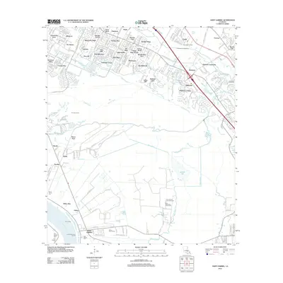
2012 Map of Saint Gabriel
USGS Topo · Published 2012About this map
Spanish Lake and its surrounding wetlands dominate the southeastern landscape of this region, illustrating the intricate hydrology of the area near the Mississippi River. In the town of Saint Gabriel, the landscape is defined by its deep ties to the river, marked by the Point Pleasant Ferry Landing and a cluster of historic burial sites such as Saint Gabriel Cem and Saint Raphael Cem. To the north, the transition from rural land to suburban development is evident in the dense residential neighborhoods like Saint George and Oak Hills Place that have emerged near the Bayou Fountain corridor. This 2012 survey also captures the persistent industrial presence in the parish, from the Burtville Oil Field to the LSU Ag Sta research facilities, alongside recreational spaces like the Saint Marie Golf Course and the Interstate Landing Strip near Kleinpeter.
Find a feature on this map
71 named features on this map. Tap any name to fly to it.
Don’t see what you’re looking for? This feature index may not catch every label — zoom into the map to look around manually.
Map Details
Editions of this 2012 Saint Gabriel Map
This is the sole edition of this map. No revisions or reprints were ever made.
Other maps of this area

1892 · Donaldsonville
USGS Topo · 1:62,500

1908 · Baton Rouge
USGS Topo · 1:62,500

1934 · Denham Springs
USGS Topo · 1:62,500

1935 · Gonzales
USGS Topo · 1:31,680

1936 · White Castle
USGS Topo · 1:62,500

1939 · Denham Springs
USGS Topo · 1:62,500

1939 · Baton Rouge
USGS Topo · 1:62,500

1939 · Donaldsonville
USGS Topo · 1:62,500

1953 · Baton Rouge West
USGS Topo · 1:24,000

1953 · Plaquemine
USGS Topo · 1:24,000