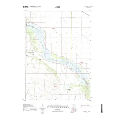
2017 Map of Saint Helena
USGS Topo · Published 2017About this map
St. Helena stands on the southern banks of the Missouri River, overlooking a complex riverine landscape within the Missouri National Recreation River corridor. This 2017 study illustrates the modern intersection of historic settlement patterns and active floodplain dynamics along the Nebraska-South Dakota border. The maps depicts significant landmarks including the Saint Helena Cemetery and the sprawling Saint Helena Island, situated where the river braids across the valley floor. Beyond the riverfront, the terrain rises into the dissected uplands of Cedar County, marked by natural features like Bow Creek and the localized development at Bow Valley Mills. The network of section lines and modern roads, such as 895th Road, highlights how the rural agricultural grid adapts to the winding course of the Missouri.
Find a feature on this map
1 named feature on this map. Tap any name to fly to it.
Don’t see what you’re looking for? This feature index may not catch every label — zoom into the map to look around manually.
Map Details
Editions of this 2017 Saint Helena Map
This is the sole edition of this map. No revisions or reprints were ever made.
Other maps of this area

1955 · Sioux City
USGS Topo · 1:250,000

1957 · Gayville
USGS Topo · 1:24,000

1957 · Mission Hill
USGS Topo · 1:24,000

1958 · Sioux City
USGS Topo · 1:250,000

1959 · Sioux City
USGS Topo · 1:250,000

1968 · Obert
USGS Topo · 1:24,000

1968 · St. Helena
USGS Topo · 1:24,000

1968 · Wynot
USGS Topo · 1:24,000
1968 · Meckling
USGS Topo · 1:24,000

1968 · Fordyce
USGS Topo · 1:24,000