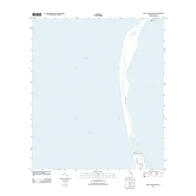
2012 Map of Saint Joseph Point
USGS Topo · Published 2012About this map
The narrow spit of Saint Joseph Peninsula defines this coastal landscape, separating the open Gulf of Mexico from the protected waters of Saint Josephs Bay. At the northernmost tip, Saint Joseph Point serves as a geographic anchor for the region's wilderness, much of which is preserved within St Joseph Peninsula SP. This coastal area shows minimal development, with small residential corridors like Secluded Dunes Dr and Bent Tree Rd branching off from Cape San Blas Rd near the southern boundary. The shifting sands and maritime topography of Eagle Harbor illustrate the dynamic environment of the Florida panhandle's barrier islands as they existed in the early twenty-first century.
Find a feature on this map
10 named features on this map. Tap any name to fly to it.
Don’t see what you’re looking for? This feature index may not catch every label — zoom into the map to look around manually.
Map Details
Editions of this 2012 Saint Joseph Point Map
This is the sole edition of this map. No revisions or reprints were ever made.
Other maps of this area

1943 · St Joseph Spit
USGS Topo · 1:31,680

1943 · Port St. Joe
USGS Topo · 1:31,680

1943 · Cape San Blas
USGS Topo · 1:31,680

1943 · Overstreet
USGS Topo · 1:31,680

1943 · Crooked Island
USGS Topo · 1:31,680

1944 · Beacon Hill
USGS Topo · 1:31,680

1945 · St Joseph Point
USGS Topo · 1:31,680

1949 · Apalachicola
USGS Topo · 1:250,000
1956 · Beacon Hill
USGS Topo · 1:24,000
1956 · Crooked Island
USGS Topo · 1:24,000