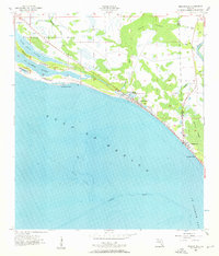
1956 Map of Beacon Hill
USGS Topo · Published 1956About this map
Mexico Beach and Beacon Hill anchor this coastal survey, where the development of the Florida Panhandle meets significant military and maritime infrastructure. The northwestern portion of the map is dominated by Tyndall Air Force Base, which at this time featured a Gunnery Range, a Tower, and a Landing Field situated along the brackish waters of St Andrew Sound. The shifting shoreline is defined by the St Andrew Peninsula and Crooked Island, sheltering internal waterways like Wild Goose Lagoon and Raffield Bayou. To the east, the landscape transitions into the dense wetlands of Bear Swamp and Panther Swamp, drained by small tributaries like Cypress Creek and Joe Lamb Br. This era captures the region before the extensive modern expansion, highlighting the local importance of specific water bodies such as Preacher Bryant Pond and the strategic Entrance channel to St Joseph Bay.
Find a feature on this map
28 named features on this map. Tap any name to fly to it.
Don’t see what you’re looking for? This feature index may not catch every label — zoom into the map to look around manually.
Map Details
Editions of this 1956 Beacon Hill Map
2 editions found
Other maps of this area

1943 · Port St. Joe
USGS Topo · 1:31,680

1943 · Overstreet
USGS Topo · 1:31,680

1943 · Crooked Island
USGS Topo · 1:31,680

1944 · Beacon Hill
USGS Topo · 1:31,680

1944 · Long Point
USGS Topo · 1:31,680

1945 · Allanton
USGS Topo · 1:31,680

1945 · Wetappo Creek
USGS Topo · 1:31,680

1945 · St Joseph Point
USGS Topo · 1:31,680

1947 · Allanton
USGS Topo · 1:25,000

1949 · Apalachicola
USGS Topo · 1:250,000