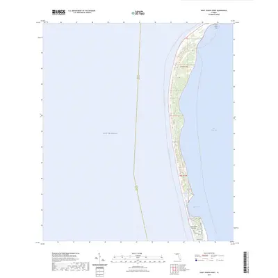
2024 Map of Saint Joseph Point
USGS Topo · Published 2024About this map
Saint Joseph Peninsula stretches narrowly between the open Gulf of Mexico and the calmer waters of Saint Joseph Bay in this 2024 coastal survey. Much of the land area is preserved within the T H Stone Memorial Saint Joseph Peninsula State Park, showing the preservation of the dune systems and maritime environment. The mapping details the transit routes along the spit, from the water-based Florida Circumnavigational Paddling Trl to land-based routes like Cabin Rd and Cape San Blas Rd. Near the southern edge of the sheet, residential development appears along Secluded Dunes Dr and Seacliff Dr at the entrance to the park, while the northern tip terminates at the remote Saint Joseph Point. This modern data illustrates the dynamic nature of the Gulf Coast shoreline and its protected habitats at Eagle Harbor.
Find a feature on this map
24 named features on this map. Tap any name to fly to it.
Don’t see what you’re looking for? This feature index may not catch every label — zoom into the map to look around manually.
Map Details
Editions of this 2024 Saint Joseph Point Map
This is the sole edition of this map. No revisions or reprints were ever made.
Other maps of this area

1943 · St Joseph Spit
USGS Topo · 1:31,680

1943 · Port St. Joe
USGS Topo · 1:31,680

1943 · Cape San Blas
USGS Topo · 1:31,680

1943 · Overstreet
USGS Topo · 1:31,680

1943 · Crooked Island
USGS Topo · 1:31,680

1944 · Beacon Hill
USGS Topo · 1:31,680

1945 · St Joseph Point
USGS Topo · 1:31,680

1949 · Apalachicola
USGS Topo · 1:250,000
1956 · Beacon Hill
USGS Topo · 1:24,000
1956 · Crooked Island
USGS Topo · 1:24,000