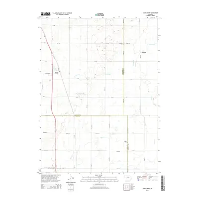
2014 Map of Saint Libory
USGS Topo · Published 2014About this map
Saint Libory and the nearby settlement of Worms anchor this agricultural region where three Nebraska counties—Howard, Hall, and Merrick—converge. The landscape is defined by its subtle drainage networks, including the meandering Prairie Slough and the winding course of Prairie Cr, which carve through the plains. Traces of local heritage are preserved at the Norwegian Cem in the north and the Weigert Cem further south, providing specific points of interest for genealogists tracing family roots in this rural community. Modern transportation centers on the north-south corridor of Us-281, while a grid of local roads such as Gunbarrel Rd N and Worms Rd maintains the historic section-line structure of the Nebraska countryside.
Find a feature on this map
47 named features on this map. Tap any name to fly to it.
Don’t see what you’re looking for? This feature index may not catch every label — zoom into the map to look around manually.
Map Details
Editions of this 2014 Saint Libory Map
This is the sole edition of this map. No revisions or reprints were ever made.
Other maps of this area

1892 · Grand Island
USGS Topo · 1:62,500

1895 · Grand Island
USGS Topo · 1:62,500

1898 · Grand Island
USGS Topo · 1:125,000

1899 · St. Paul
USGS Topo · 1:125,000

1955 · Broken Bow
USGS Topo · 1:250,000

1955 · Grand Island
USGS Topo · 1:250,000

1956 · Broken Bow
USGS Topo · 1:250,000

1957 · Grand Island
USGS Topo · 1:250,000

1958 · Grand Island
USGS Topo · 1:250,000
1960 · St. Paul
USGS Topo · 1:24,000