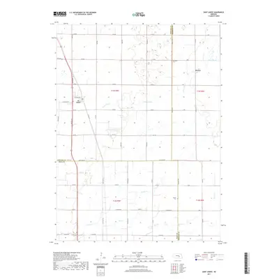
2017 Map of Saint Libory
USGS Topo · Published 2017About this map
St. Libory and the village of Worms anchor this Nebraska landscape, where the prairie begins to give way to the irrigated agricultural fields typical of the region. The map reveals a meticulous grid of rural roads such as Merrick Rd and Denton Rd, which define the section lines and manage the flow of travel through central Howard County. Waterways like Prairie Slough and Prairie Cr meander through the terrain, suggesting the importance of drainage and natural irrigation in this plains environment. Local history is grounded in the presence of the Norwegian Cem and Weigert Cem, marking the heritage of the early families who established these communities. The intersection of local transit and civic life is centered at the Po in St. Libory, providing a focal point for the surrounding farmsteads.
Find a feature on this map
52 named features on this map. Tap any name to fly to it.
Don’t see what you’re looking for? This feature index may not catch every label — zoom into the map to look around manually.
Map Details
Editions of this 2017 Saint Libory Map
This is the sole edition of this map. No revisions or reprints were ever made.
Other maps of this area

1892 · Grand Island
USGS Topo · 1:62,500

1895 · Grand Island
USGS Topo · 1:62,500

1898 · Grand Island
USGS Topo · 1:125,000

1899 · St. Paul
USGS Topo · 1:125,000

1955 · Broken Bow
USGS Topo · 1:250,000

1955 · Grand Island
USGS Topo · 1:250,000

1956 · Broken Bow
USGS Topo · 1:250,000

1957 · Grand Island
USGS Topo · 1:250,000

1958 · Grand Island
USGS Topo · 1:250,000
1960 · St. Paul
USGS Topo · 1:24,000