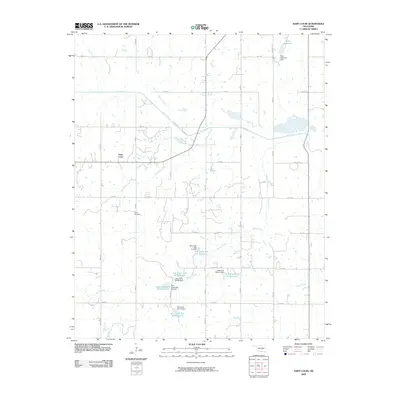
2009 Map of Saint Louis
USGS Topo · Published 2009About this map
Saint Louis serves as the central hub of this Oklahoma landscape, surrounded by an extensive network of water management features and rural infrastructure. The area is defined by its numerous tributary creeks, including Marcum Creek, Bruno Creek, and Popshego Creek, which feed into the larger Salt Creek. The early 21st-century topography reveals a significant focus on water conservation and flood control, evidenced by a series of numbered impoundments such as the Salt Creek Site 39 Reservoir and Salt Creek Site 40 Reservoir. Genealogists and local historians can locate Collins Cemetery south of the main settlement, situated among a grid of section roads like n3460 RD and e1350 RD. To the north, the Katy Reservoir and its associated Katy Reservoir Dam represent a primary landmark for the region.
Find a feature on this map
43 named features on this map. Tap any name to fly to it.
Don’t see what you’re looking for? This feature index may not catch every label — zoom into the map to look around manually.
Map Details
Editions of this 2009 Saint Louis Map
This is the sole edition of this map. No revisions or reprints were ever made.
Other maps of this area

1896 · Seminole and Prague
USGS Topo · 1:125,000

1901 · Stonewall
USGS Topo · 1:125,000

1907 · Maud
USGS Topo · 1:62,500

1908 · Maud
USGS Topo · 1:62,500

1954 · Oklahoma City
USGS Topo · 1:250,000

1957 · Ardmore
USGS Topo · 1:250,000

1957 · Oklahoma City
USGS Topo · 1:250,000
1958 · Pearson
USGS Topo · 1:24,000

1958 · Vamoosa
USGS Topo · 1:24,000

1958 · Konawa
USGS Topo · 1:24,000