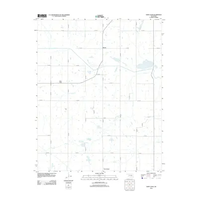
2012 Map of Saint Louis
USGS Topo · Published 2012About this map
Saint Louis and Sacred Heart anchor this central Oklahoma landscape, where the rural grid is defined by the complex drainage of Salt Cr and its numerous tributaries. The area's water management is evident through a series of numbered flood control structures, including Salt Cr Site 37 Reservoir and several neighboring basins that follow the southern path of Bruno Cr. This region, traditionally agrarian with a history of small-town centers like Ellaville, is mapped here at a scale of 1:24,000, revealing the modern road network where thoroughfares like Broadway Ave connect the scattered settlements. Genealogists will find the location of Collins Cem a valuable point of reference, while the presence of Katy Reservoir in the northeast corner hints at the earlier industrial influence of the railroad through this prairie and creek-cut terrain.
Find a feature on this map
35 named features on this map. Tap any name to fly to it.
Don’t see what you’re looking for? This feature index may not catch every label — zoom into the map to look around manually.
Map Details
Editions of this 2012 Saint Louis Map
This is the sole edition of this map. No revisions or reprints were ever made.
Other maps of this area

1896 · Seminole and Prague
USGS Topo · 1:125,000

1901 · Stonewall
USGS Topo · 1:125,000

1907 · Maud
USGS Topo · 1:62,500

1908 · Maud
USGS Topo · 1:62,500

1954 · Oklahoma City
USGS Topo · 1:250,000

1957 · Ardmore
USGS Topo · 1:250,000

1957 · Oklahoma City
USGS Topo · 1:250,000
1958 · Pearson
USGS Topo · 1:24,000

1958 · Vamoosa
USGS Topo · 1:24,000

1958 · Konawa
USGS Topo · 1:24,000