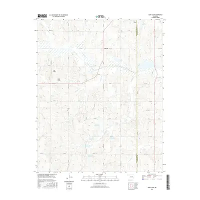
2016 Map of Saint Louis
USGS Topo · Published 2016About this map
St. Louis and Maud anchor this 2016 survey along the boundary of Pottawatomie and Seminole counties. The landscape is defined by a dense network of sectional roads and the winding path of Salt Creek, which is fed by numerous tributaries including Marcum Cr, Popshego Cr, and Bruno Cr. The map reveals a managed water system south of the primary settlements, characterized by a series of reservoirs such as Salt Cr Site 37 Reservoir and Salt Cr Site 41 Reservoir, likely designed for flood control or agricultural use in the rolling terrain. Local history and genealogy interests are centered on the small community of Ellaville and the isolated Collins Cem. The naming of Katy Reservoir in the northeast corner provides a subtle nod to the region's rail heritage, even as modern routes like Sacred Heart Rd and N State St facilitate contemporary travel between these rural centers.
Find a feature on this map
52 named features on this map. Tap any name to fly to it.
Don’t see what you’re looking for? This feature index may not catch every label — zoom into the map to look around manually.
Map Details
Editions of this 2016 Saint Louis Map
This is the sole edition of this map. No revisions or reprints were ever made.
Other maps of this area

1896 · Seminole and Prague
USGS Topo · 1:125,000

1901 · Stonewall
USGS Topo · 1:125,000

1907 · Maud
USGS Topo · 1:62,500

1908 · Maud
USGS Topo · 1:62,500

1954 · Oklahoma City
USGS Topo · 1:250,000

1957 · Ardmore
USGS Topo · 1:250,000

1957 · Oklahoma City
USGS Topo · 1:250,000
1958 · Pearson
USGS Topo · 1:24,000

1958 · Vamoosa
USGS Topo · 1:24,000

1958 · Konawa
USGS Topo · 1:24,000