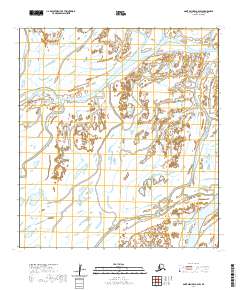
2020 Map of Saint Michael A-4 SW
USGS Topo · Published 2020About this map
Okshokwewhik Pass cuts through a dense network of wetlands in this coastal Alaska landscape, where the shifting boundaries of the Yukon-Kuskokwim Delta are defined by slow-moving water. The area is dominated by an intricate system of sloughs and passes, most notably Apoon Pass and Apakshau Slough in the southeast. These waterways surround Pieneluk Island, a landform shaped by the surrounding Pieneluk Slough and Kaweohnak Slough. The topographic data reveals a nearly level terrain where subtle elevation changes dictate the flow of the delta's distributaries. This 2020 survey provides a modern record of this fluid environment, useful for understanding the hydrography of the Kusilvak Census Area.
Find a feature on this map
12 named features on this map. Tap any name to fly to it.
Don’t see what you’re looking for? This feature index may not catch every label — zoom into the map to look around manually.
Map Details
Editions of this 2020 Saint Michael A-4 SW Map
This is the sole edition of this map. No revisions or reprints were ever made.
Other maps of this area

1951 · St Michael
USGS Topo · 1:250,000

1952 · Kwiguk
USGS Topo · 1:250,000

1952 · Saint Michael A-5
USGS Topo · 1:63,360
1952 · Saint Michael A-4
USGS Topo · 1:63,360

1952 · Kwiguk D-5
USGS Topo · 1:63,360

1952 · Kwiguk D-4
USGS Topo · 1:63,360

1952 · St Michael
USGS Topo · 1:250,000

1964 · St. Michael
USGS Topo · 1:250,000
2020 · Kwiguk D-4 NE
USGS Topo · 1:25,000
2020 · Saint Michael A-5 NE
USGS Topo · 1:25,000