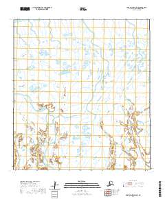
2020 Map of Saint Michael A-5 NE
USGS Topo · Published 2020About this map
Norton Sound defines the northwest corner of this coastal landscape in the Kusilvak Census Area. The map details a complex wetland environment dominated by winding waterways, most notably Uwik Slough in the northern reach and Elongozhik Slough at the southern edge. The lack of terrestrial roads or settlements highlights the isolation of this delta region, where the terrain is governed by tidal influence and seasonal hydrological shifts. This topographic study focuses on the intricate network of ponds and channels that characterize the Alaskan tundra, providing a detailed record of the shifting water boundaries within the t26s r29w and t27s r28w townships. Researchers can use this data to understand the precise layout of the coastal marshes as they existed at the turn of the decade.
Find a feature on this map
7 named features on this map. Tap any name to fly to it.
Don’t see what you’re looking for? This feature index may not catch every label — zoom into the map to look around manually.
Map Details
Editions of this 2020 Saint Michael A-5 NE Map
This is the sole edition of this map. No revisions or reprints were ever made.
Other maps of this area

1951 · St Michael
USGS Topo · 1:250,000

1952 · Saint Michael A-5
USGS Topo · 1:63,360
1952 · Saint Michael A-4
USGS Topo · 1:63,360

1952 · St Michael
USGS Topo · 1:250,000

1964 · St. Michael
USGS Topo · 1:250,000
2020 · Saint Michael A-5 SW
USGS Topo · 1:25,000
2020 · Saint Michael A-4 NW
USGS Topo · 1:25,000
2020 · Saint Michael A-4 OE N SW
USGS Topo · 1:25,000
2020 · Saint Michael A-5 OE N SE
USGS Topo · 1:25,000
2020 · Saint Michael A-4 SW
USGS Topo · 1:25,000