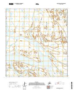
2020 Map of Saint Michael A-5 SW
USGS Topo · Published 2020About this map
The branching waterways of the Yukon River delta define this coastal landscape, where Kwikpak Pass and Kawanak Pass create a complex network of channels and marshlands. These major distributaries are the primary features of the Kusilvak Census Area shown here, facilitating travel and seasonal subsistence activities in a region where water routes are the only highways. The intersection of these passes near Sea Gull Point illustrates the dynamic nature of the delta, as sediment and seasonal flows continuously reshape the banks. To the east, the Durukchavuk Slough meanders through the wetlands, while Kochluk Pass cuts through the northwest, highlighting the intricate hydrological patterns of this subarctic environment. The lack of roads or permanent settlements emphasizes the role of these waterways as the lifeblood of the coastal tundra.
Find a feature on this map
14 named features on this map. Tap any name to fly to it.
Don’t see what you’re looking for? This feature index may not catch every label — zoom into the map to look around manually.
Map Details
Editions of this 2020 Saint Michael A-5 SW Map
This is the sole edition of this map. No revisions or reprints were ever made.
Other maps of this area

1951 · St Michael
USGS Topo · 1:250,000

1952 · Kwiguk
USGS Topo · 1:250,000

1952 · Saint Michael A-5
USGS Topo · 1:63,360
1952 · Saint Michael A-6
USGS Topo · 1:63,360

1952 · Kwiguk D-6
USGS Topo · 1:63,360

1952 · Kwiguk D-5
USGS Topo · 1:63,360

1952 · St Michael
USGS Topo · 1:250,000

1964 · St. Michael
USGS Topo · 1:250,000
2020 · Saint Michael A-5 NE
USGS Topo · 1:25,000
2020 · Saint Michael A-6 SE
USGS Topo · 1:25,000