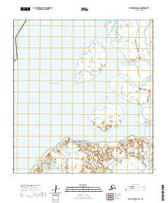
2020 Map of Saint Michael A-6 SE
USGS Topo · Published 2020About this map
Norton Sound meets the sprawling delta of the Yukon River system in this 2020 survey of the Alaska coast. The landscape is defined by massive marshy landmasses including Nunaktuk Island and Nokogamiut Island, which are separated by a complex network of tidally influenced waterways. To the north, Kothlik Island sits near the confluence of major distributary channels. The hydraulic character of the region is traced through the Kawanak Channel, Kwikpak Pass, and Kothlik Pass, illustrating the shifting alluvial patterns of the Kusilvak Census Area. This map provides a precise modern record of shoreline boundaries and hydrography in a remote maritime environment where land and water frequently intermingle.
Find a feature on this map
12 named features on this map. Tap any name to fly to it.
Don’t see what you’re looking for? This feature index may not catch every label — zoom into the map to look around manually.
Map Details
Editions of this 2020 Saint Michael A-6 SE Map
This is the sole edition of this map. No revisions or reprints were ever made.
Other maps of this area

1951 · St Michael
USGS Topo · 1:250,000

1952 · Kwiguk
USGS Topo · 1:250,000

1952 · Saint Michael A-5
USGS Topo · 1:63,360
1952 · Saint Michael A-6
USGS Topo · 1:63,360

1952 · Kwiguk D-6
USGS Topo · 1:63,360

1952 · Kwiguk D-5
USGS Topo · 1:63,360

1952 · St Michael
USGS Topo · 1:250,000

1964 · St. Michael
USGS Topo · 1:250,000
2020 · Saint Michael A-5 SW
USGS Topo · 1:25,000
2020 · Saint Michael A-6 SW
USGS Topo · 1:25,000