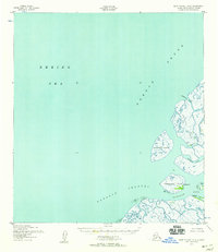
1952 Map of Saint Michael A-6
USGS Topo · Published 1958About this map
Norton Sound and the Bering Sea dominate this mid-century survey of the Yukon-Kuskokwim Delta region. The map highlights a complex network of coastal waterways including the Kawanak Channel and Kwikpak Pass, which define the low-lying terrain of Kothlik Island and Nunaktuk Island. Small settlements and seasonal locations like Nokogamiut, located on its eponymous Nokogamiut Island, and Ageklekak suggest the subsistence patterns of the area before modern infrastructure arrived. A lone Cabin on Kothlik Island provides a specific point of interest for those tracking historical occupancy and local geographic landmarks. The mapping, based on 1951 aerial photography, illustrates the intricate distributary channels and mudflats where Kawanak Pass and Kochluk Pass navigate the delta shoreline.
Find a feature on this map
12 named features on this map. Tap any name to fly to it.
Don’t see what you’re looking for? This feature index may not catch every label — zoom into the map to look around manually.
Map Details
Editions of this 1952 Saint Michael A-6 Map
2 editions found
Other maps of this area

1951 · Black
USGS Topo · 1:250,000

1951 · St Michael
USGS Topo · 1:250,000

1952 · Kwiguk
USGS Topo · 1:250,000

1952 · Saint Michael A-5
USGS Topo · 1:63,360

1952 · Kwiguk D-6
USGS Topo · 1:63,360

1952 · Kwiguk D-5
USGS Topo · 1:63,360

1952 · St Michael
USGS Topo · 1:250,000

1964 · St. Michael
USGS Topo · 1:250,000
2020 · Saint Michael A-5 SW
USGS Topo · 1:25,000
2020 · Saint Michael A-6 SW
USGS Topo · 1:25,000