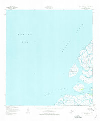
1952 Map of Saint Michael A-6
USGS Topo · Published 1974About this map
Nokogamiut and Ageklekak sit within a labyrinth of tidal channels and islands where the Bering Sea meets the Yukon Delta. This early 1950s survey documents the complex hydrology of the Kawanak Channel and its associated passes, showing a landscape defined more by water than solid ground. The eastern portion of the map is dominated by the Clarence Rhode National Wildlife Range, encompassing large landmasses like Kothlik Island.
Find a feature on this map
16 named features on this map. Tap any name to fly to it.
Don’t see what you’re looking for? This feature index may not catch every label — zoom into the map to look around manually.
Map Details
Editions of this 1952 Saint Michael A-6 Map
2 editions found
Other maps of this area

1951 · Black
USGS Topo · 1:250,000

1951 · St Michael
USGS Topo · 1:250,000

1952 · Kwiguk
USGS Topo · 1:250,000

1952 · Saint Michael A-5
USGS Topo · 1:63,360
1952 · Saint Michael A-6
USGS Topo · 1:63,360

1952 · Kwiguk D-6
USGS Topo · 1:63,360

1952 · Kwiguk D-5
USGS Topo · 1:63,360

1952 · St Michael
USGS Topo · 1:250,000

1964 · St. Michael
USGS Topo · 1:250,000
2020 · Saint Michael A-5 SW
USGS Topo · 1:25,000