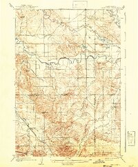
1905 Map of Saint Onge
USGS Topo · Published 1941About this map
The Belle Fourche River meanders across this northern Black Hills landscape, dividing the rolling ranchlands of Butte and Lawrence counties. Surveyed in 1903, the map captures the early development of the region's agricultural and transport corridors, notably the Chicago and Northwestern railroad line that skirts the southwestern hills. The settlement of Saint Onge serves as a focal point near the prominent Saint Onge Peak, while the small community of Snoma sits just south of the river. The presence of the Redwater Ditch illustrates the early reliance on organized irrigation to support the valley's growth. Scattered topographic landmarks like Susie Pk, Haystack Buttes, and Miller Butte provide clear navigational markers for those tracing old family property lines or historic paths through these drainage basins.
Find a feature on this map
22 named features on this map. Tap any name to fly to it.
Don’t see what you’re looking for? This feature index may not catch every label — zoom into the map to look around manually.
Map Details
Editions of this 1905 Saint Onge Map
2 editions found
Other maps of this area

1893 · Rapid
USGS Topo · 1:125,000

1894 · Deadwood
USGS Topo · 1:125,000

1898 · Rapid
USGS Topo · 1:125,000

1899 · Sturgis
USGS Topo · 1:62,500

1900 · Spearfish
USGS Topo · 1:62,500

1901 · Deadwood
USGS Topo · 1:125,000

1903 · Rapid
USGS Topo · 1:125,000

1905 · Saint Onge
USGS Topo · 1:62,500
1905 · Indian
USGS Topo · 1:62,500

1906 · Two Top
USGS Topo · 1:62,500