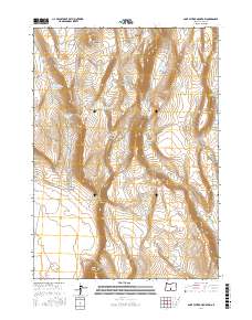
2017 Map of Saint Patrick Mountain
USGS Topo · Published 2017About this map
Saint Patrick Mtn dominates the high desert landscape of Lake County in this 2017 survey, serving as a focal point for a complex network of water management features. The area's reliance on seasonal and collected water is evident through numerous specialized labels, such as Saint Patrick Reservoir, Settlement Waterhole, and Spur Rowel Lake. These water sources are scattered across varied terrain that includes the prominent Diablo Rim to the south and the sheltered Coffeepot Basin to the northeast.
Find a feature on this map
28 named features on this map. Tap any name to fly to it.
Don’t see what you’re looking for? This feature index may not catch every label — zoom into the map to look around manually.
Map Details
Editions of this 2017 Saint Patrick Mountain Map
This is the sole edition of this map. No revisions or reprints were ever made.
Other maps of this area

1955 · Crescent
USGS Topo · 1:250,000

1955 · Klamath Falls
USGS Topo · 1:250,000

1957 · Crescent
USGS Topo · 1:250,000

1958 · Crescent
USGS Topo · 1:250,000

1958 · Klamath Falls
USGS Topo · 1:250,000

1970 · Crescent
USGS Topo · 1:250,000

1974 · Lake Abert
USGS Topo · 1:100,000

1986 · St. Patrick Mtn.
USGS Topo · 1:24,000
1986 · Christmas Valley
USGS Topo · 1:24,000
1986 · Ana River
USGS Topo · 1:24,000