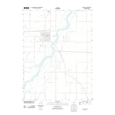
2011 Map of Saint Paul
USGS Topo · Published 2011About this map
Saint Paul serves as the central hub of this Nebraska landscape, situated at the confluence of several significant watercourses and transport routes. The town’s grid is anchored by the Saint Paul Post Office and extends southward toward the Saint Paul Cemetery. The winding course of the Middle Loup River dominates the western and southern reaches of the quadrangle, joined by tributaries such as Lake Creek, Turkey Creek, and the drainage of Big Slough. This network of waterways implies a valley floor shaped by alluvial processes, long supporting the agricultural and civic life of Howard County.
Find a feature on this map
31 named features on this map. Tap any name to fly to it.
Don’t see what you’re looking for? This feature index may not catch every label — zoom into the map to look around manually.
Map Details
Editions of this 2011 Saint Paul Map
This is the sole edition of this map. No revisions or reprints were ever made.
Other maps of this area

1899 · Loup
USGS Topo · 1:125,000

1899 · St. Paul
USGS Topo · 1:125,000

1953 · Dannebrog
USGS Topo · 1:24,000

1953 · Nysted
USGS Topo · 1:24,000

1953 · Elba
USGS Topo · 1:24,000

1955 · Broken Bow
USGS Topo · 1:250,000

1955 · Wolbach SW
USGS Topo · 1:24,000

1955 · Cushing
USGS Topo · 1:24,000

1956 · Broken Bow
USGS Topo · 1:250,000
1960 · St. Paul
USGS Topo · 1:24,000