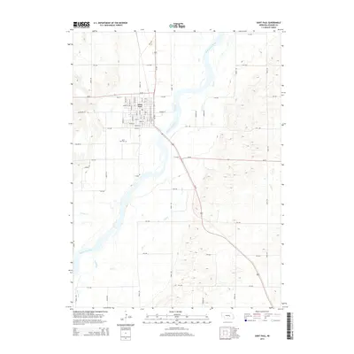
2014 Map of Saint Paul
USGS Topo · Published 2014About this map
Saint Paul sits at the heart of this Howard County landscape, organized around a dense grid of streets including Adams St, Kendall St, and Sherman St. This agricultural and riverfront community is defined by its proximity to the Middle Loup River, which creates a wide, braided alluvial corridor across the southwestern portion of the sheet. Outside the town center, the land is partitioned by a strictly regular section-line road network, featuring routes such as 8th Ave and Jansen Rd. To the west of the main settlement lies the Saint Paul Cem, a primary point of interest for genealogists tracking local families. The hydrology of the area is quite complex, with various smaller watercourses like Lake Cr, Big Slough, and Turkey Cr threading through the low-lying terrain near the river valley, illustrating the drainage patterns that have historically shaped local land use and development.
Find a feature on this map
49 named features on this map. Tap any name to fly to it.
Don’t see what you’re looking for? This feature index may not catch every label — zoom into the map to look around manually.
Map Details
Editions of this 2014 Saint Paul Map
This is the sole edition of this map. No revisions or reprints were ever made.
Other maps of this area

1899 · Loup
USGS Topo · 1:125,000

1899 · St. Paul
USGS Topo · 1:125,000

1953 · Dannebrog
USGS Topo · 1:24,000

1953 · Nysted
USGS Topo · 1:24,000

1953 · Elba
USGS Topo · 1:24,000

1955 · Broken Bow
USGS Topo · 1:250,000

1955 · Wolbach SW
USGS Topo · 1:24,000

1955 · Cushing
USGS Topo · 1:24,000

1956 · Broken Bow
USGS Topo · 1:250,000
1960 · St. Paul
USGS Topo · 1:24,000