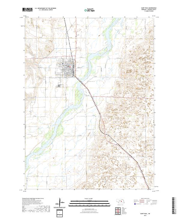
2021 Map of Saint Paul
USGS Topo · Published 2021About this map
St. Paul serves as the focal point of this Nebraska landscape, where the street grid is anchored by the Howard County Courthouse. The town’s development is bounded by the winding course of the Middle Loup River, which creates a complex network of wetlands and shifting sandbars to the south and east. Notable local landmarks include the Elmwood Cem on the southwestern edge of town and several water features such as Turkey Cr, Big Slough, and Lake Cr. The surrounding countryside is defined by a rigid section-line road system, with routes like Hardy Rd and Eagle Rd connecting the agricultural blocks of T14N and T15N. This survey documents the intersection of civic structure and a dynamic riverine environment in central Nebraska.
Find a feature on this map
44 named features on this map. Tap any name to fly to it.
Don’t see what you’re looking for? This feature index may not catch every label — zoom into the map to look around manually.
Map Details
Editions of this 2021 Saint Paul Map
This is the sole edition of this map. No revisions or reprints were ever made.
Other maps of this area

1899 · Loup
USGS Topo · 1:125,000

1899 · St. Paul
USGS Topo · 1:125,000

1953 · Dannebrog
USGS Topo · 1:24,000

1953 · Nysted
USGS Topo · 1:24,000

1953 · Elba
USGS Topo · 1:24,000

1955 · Broken Bow
USGS Topo · 1:250,000

1955 · Wolbach SW
USGS Topo · 1:24,000

1955 · Cushing
USGS Topo · 1:24,000

1956 · Broken Bow
USGS Topo · 1:250,000
1960 · St. Paul
USGS Topo · 1:24,000