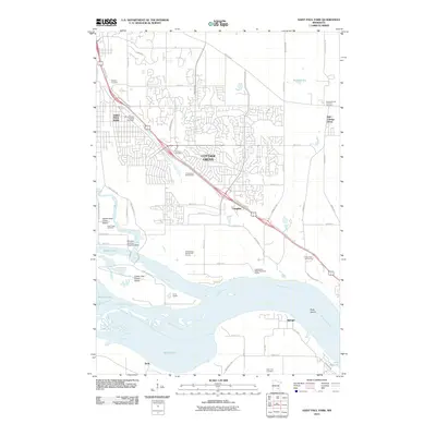
2010 Map of Saint Paul Park
USGS Topo · Published 2010About this map
The Mississippi River carves a wide path through this portion of Washington County, defining the geography between the suburban expansion of Saint Paul Park and the rural reaches of Nininger. The landscape is notably marked by several islands and backwaters, including Upper Grey Cloud Island, Lower Grey Cloud Island, and Buck Island, which sit nestled between Mooers Lake and Baldwin Lake. This 2010 survey highlights a transition from industrial and residential corridors to recreational spaces such as the Mississippi Dunes Golf Course and River Oaks Golf Course. Genealogy researchers will find significant value in the high density of burial sites across the quadrangle, including the Saint Thomas Aquinas Cemetery, Hinton Cemetery, and the East Cottage Grove Cemetery. On the river's edge, specialized facilities like the Winners Landing Seaplane Base and Camp Galilee reflect the area's long-standing connection to the water, while the inland settlement of Langdon anchors the central road network.
Find a feature on this map
68 named features on this map. Tap any name to fly to it.
Don’t see what you’re looking for? This feature index may not catch every label — zoom into the map to look around manually.
Map Details
Editions of this 2010 Saint Paul Park Map
This is the sole edition of this map. No revisions or reprints were ever made.
Other maps of this area

1896 · St. Paul
USGS Topo · 1:62,500

1946 · Hudson
USGS Topo · 1:62,500

1949 · Hudson
USGS Topo · 1:62,500

1949 · Lake Elmo
USGS Topo · 1:24,000

1949 · Hudson
USGS Topo · 1:24,000

1950 · Lake Elmo
USGS Topo · 1:24,000

1950 · Hudson
USGS Topo · 1:24,000

1950 · St Paul Park
USGS Topo · 1:24,000

1951 · St Paul Park
USGS Topo · 1:24,000

1951 · Prescott
USGS Topo · 1:24,000