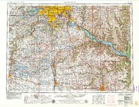
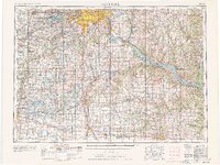
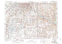
1953 Map of Saint Paul
USGS Topo · Published 1979About this map
The Mississippi River and the Minnesota River converge at the historic heart of the Twin Cities, where the Fort Snelling Military Reservation sits as a central landmark. This mid-century survey, updated in the late 1970s, captures the post-war expansion of Minneapolis and Saint Paul as suburbs like Bloomington, Edina, and Richfield began to fill the landscape between the urban core and the expansive Lake Minnetonka to the west.
Find a feature on this map
122 named features on this map. Tap any name to fly to it.
Don’t see what you’re looking for? This feature index may not catch every label — zoom into the map to look around manually.
Map Details
Editions of this 1953 Saint Paul Map
4 editions found

Other maps of this area

1896 · Minneapolis
USGS Topo · 1:62,500

1896 · St. Paul
USGS Topo · 1:62,500

1901 · Minneapolis
USGS Topo · 1:62,500

1902 · White Bear
USGS Topo · 1:62,500

1902 · Anoka
USGS Topo · 1:62,500

1905 · Minnetonka
USGS Topo · 1:62,500

1907 · Minnetonka
USGS Topo · 1:62,500

1909 · Rockford
USGS Topo · 1:62,500

1929 · Durand
USGS Topo · 1:62,500

1932 · Cochrane
USGS Topo · 1:62,500