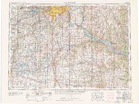
1953 Map of St. Paul
USGS Topo · Published 1978About this map
The confluence of the Mississippi River and the Minnesota River serves as the focal point for the Twin Cities and their mid-century expansion. This regional overview, compiled by the Army Map Service and field-checked in the early 1950s, details a landscape defined by its glacial lakes and a complex rail network that fueled the Upper Midwest economy. Institutional landmarks like the University of Minnesota, the State Capitol, and Fort Snelling anchor the urban core of St Paul and Minneapolis, while established suburbs such as Edina and Richfield show the post-war residential growth pattern. To the south and east, the map traces the fertile valley towards Rochester and the scenic expansion of the Mississippi at Lake Pepin. The density of small settlements and rural landmarks, including St Marys Church and numerous scattered school sites, provides a detailed record for genealogical research in the counties surrounding the metropolitan hub.
Find a feature on this map
209 named features on this map. Tap any name to fly to it.
Don’t see what you’re looking for? This feature index may not catch every label — zoom into the map to look around manually.
Map Details
Editions of this 1953 St. Paul Map
4 editions found

Other maps of this area

1896 · Minneapolis
USGS Topo · 1:62,500

1896 · St. Paul
USGS Topo · 1:62,500

1901 · Minneapolis
USGS Topo · 1:62,500

1902 · White Bear
USGS Topo · 1:62,500

1902 · Anoka
USGS Topo · 1:62,500

1905 · Minnetonka
USGS Topo · 1:62,500

1907 · Minnetonka
USGS Topo · 1:62,500

1909 · Rockford
USGS Topo · 1:62,500

1929 · Durand
USGS Topo · 1:62,500

1932 · Cochrane
USGS Topo · 1:62,500