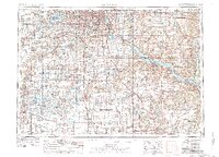
1953 Map of Saint Paul
USGS Topo · Published 1979About this map
Saint Paul and Minneapolis anchor this regional perspective of the Upper Mississippi River valley, showing the Twin Cities as they evolved during the mid-20th century. The intricate shoreline of Lake Minnetonka and the surrounding basin of smaller lakes like Lake Waconia and Lake Auburn define the western landscape, which was increasingly connected by the rising interstate system and established lines of the Chicago Milwaukee Saint Paul and Pacific railroad. The confluence of the St Croix River and the Mississippi highlights a transport corridor that shaped early settlements from Hastings to Red Wing.
Find a feature on this map
269 named features on this map. Tap any name to fly to it.
Don’t see what you’re looking for? This feature index may not catch every label — zoom into the map to look around manually.
Map Details
Editions of this 1953 Saint Paul Map
4 editions found

Other maps of this area

1896 · Minneapolis
USGS Topo · 1:62,500

1896 · St. Paul
USGS Topo · 1:62,500

1901 · Minneapolis
USGS Topo · 1:62,500

1902 · White Bear
USGS Topo · 1:62,500

1902 · Anoka
USGS Topo · 1:62,500

1905 · Minnetonka
USGS Topo · 1:62,500

1907 · Minnetonka
USGS Topo · 1:62,500

1909 · Rockford
USGS Topo · 1:62,500

1929 · Durand
USGS Topo · 1:62,500

1932 · Cochrane
USGS Topo · 1:62,500