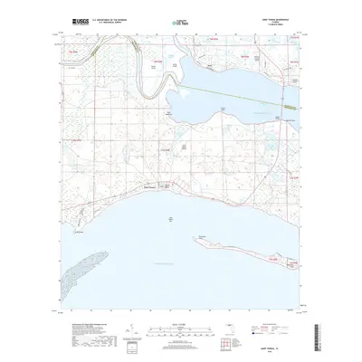
2018 Map of Saint Teresa
USGS Topo · Published 2018About this map
Ochlockonee Bay dominates this coastal landscape, where the Ochlockonee River and Sopchoppy River converge before meeting the Gulf of Mexico. The coastal communities of Saint Teresa and Surf are situated along the southern and northern shores, respectively, illustrating the settlement patterns of this low-lying marshy region. The map highlights significant maritime and aviation infrastructure, including the Wakulla County Airport and the Walker Bridge spanning the bay. Notable landmarks like Wilson Beach, Turkey Point, and the long reaching arm of Southwest Cape define the intricate shoreline. Interior features such as Halfway Lake and Corn Landing Lake reveal the numerous freshwater basins scattered across Saint James Island, while the boundary between Wakulla County and Franklin County traces a path through the river channels.
Find a feature on this map
50 named features on this map. Tap any name to fly to it.
Don’t see what you’re looking for? This feature index may not catch every label — zoom into the map to look around manually.
Map Details
Editions of this 2018 Saint Teresa Map
This is the sole edition of this map. No revisions or reprints were ever made.
Other maps of this area

1940 · Arran
USGS Topo · 1:62,500

1943 · Arran
USGS Topo · 1:62,500

1943 · Dog Island
USGS Topo · 1:31,680

1943 · St. Teresa Beach
USGS Topo · 1:24,000

1943 · Lighthouse Point
USGS Topo · 1:24,000

1945 · Lighthouse Point
USGS Topo · 1:31,680

1945 · Mc Intyre
USGS Topo · 1:31,680

1945 · St Teresa
USGS Topo · 1:31,680

1945 · Sanborn
USGS Topo · 1:31,680

1949 · Apalachicola
USGS Topo · 1:250,000