
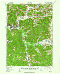
1938 Map of Salamanca
USGS Topo · Published 1954About this map
The Allegheny River valley forms the geographic and industrial spine of this region, where the Erie and Baltimore and Ohio railroads converge at bustling rail centers like Salamanca Junction and Riverside Junction. The map captures a landscape defined by significant public and tribal lands, with the northern reaches of Allegany State Park and the broad Allegheny Reservation flanking the riverbanks. Settlement patterns follow the narrow creek valleys that cut through the high ground, leading to rural hamlets such as Humphrey Center and Irvine Mills. Local industry is evidenced by the presence of the Golden Hill Lookout and the clustered developments at East Salamanca and West Salamanca. Topographic details reveal the complex network of hollows and runs, including Mutton Hollow and Limestone Brook, which shaped the early development of Cattaraugus County prior to mid-century modernizations.
Find a feature on this map
67 named features on this map. Tap any name to fly to it.
Don’t see what you’re looking for? This feature index may not catch every label — zoom into the map to look around manually.
Map Details
Editions of this 1938 Salamanca Map
2 editions found
Other maps of this area

1898 · Olean
USGS Topo · 1:62,500

1900 · Salamanca
USGS Topo · 1:62,500

1922 · Randolph
USGS Topo · 1:62,500

1923 · Randolph
USGS Topo · 1:62,500

1923 · Cattaraugus
USGS Topo · 1:62,500

1924 · Ellicottville
USGS Topo · 1:62,500

1924 · Bradford
USGS Topo · 1:62,500

1924 · Franklinville
USGS Topo · 1:62,500

1926 · Bradford
USGS Topo · 1:62,500

1933 · Smethport
USGS Topo · 1:62,500