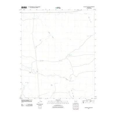
2010 Map of Salazar Canyon
USGS Topo · Published 2010About this map
Goesling Ranch and Piedres Lumbres sit within a landscape defined by an intricate network of drainage systems and livestock water improvements in Catron County. The topography is dominated by the prominent Salazar Canyon and LA Canyon, which channel seasonal runoff toward the north and west. Strategic water management for ranching is evident through the placement of various catchment features like Jercka Lake, Rim Tank, and Wire Corral Tank across the high ground. In the northeast, Cañon de Juei cuts through the terrain near a localized Rock Pit, indicating small-scale resource extraction. This area, accessed primarily by unpaved routes like County Rd-A001, preserves the character of New Mexico's rangelands, where water sources like Agua Fria Creek and Carrizo Wash dictate the pattern of human activity and movement.
Find a feature on this map
17 named features on this map. Tap any name to fly to it.
Don’t see what you’re looking for? This feature index may not catch every label — zoom into the map to look around manually.
Map Details
Editions of this 2010 Salazar Canyon Map
This is the sole edition of this map. No revisions or reprints were ever made.
Other maps of this area

1886 · St Johns
USGS Topo · 1:250,000

1892 · St Johns
USGS Topo · 1:250,000

1954 · Saint Johns
USGS Topo · 1:250,000

1957 · Saint Johns
USGS Topo · 1:250,000

1958 · Saint Johns
USGS Topo · 1:250,000

1962 · Saint Johns
USGS Topo · 1:250,000

1971 · Mesa Parada
USGS Topo · 1:24,000
1971 · The Rincon
USGS Topo · 1:24,000

1972 · Zuni Salt Lake
USGS Topo · 1:24,000

1972 · Twentytwo Spring
USGS Topo · 1:24,000