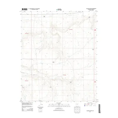
2013 Map of Salazar Canyon
USGS Topo · Published 2013About this map
Goesling Ranch sits among a complex system of seasonal drainages and water management features in this corner of Catron County. The landscape is defined by the broad courses of Carrizo Wash and Mays Wash, which intersect a series of canyons such as Salazar Canyon and the notable Cañon de Juei. Ranching and land management are evident through the numerous man-made tanks distributed across the sections, including Trail Tank, Rim Tank, and Wire Corral Tank. These water sources, along with Jercka Lake, provided critical infrastructure for livestock in an arid environment. Transportation is limited to a few arterial routes like NM-191 and local connectors such as Co Road a002. The presence of a Rock Pit indicates small-scale local resource extraction amidst the terrain of Piedres Lumbres and the prominent Red Hill Draw.
Find a feature on this map
25 named features on this map. Tap any name to fly to it.
Don’t see what you’re looking for? This feature index may not catch every label — zoom into the map to look around manually.
Map Details
Editions of this 2013 Salazar Canyon Map
This is the sole edition of this map. No revisions or reprints were ever made.
Other maps of this area

1886 · St Johns
USGS Topo · 1:250,000

1892 · St Johns
USGS Topo · 1:250,000

1954 · Saint Johns
USGS Topo · 1:250,000

1957 · Saint Johns
USGS Topo · 1:250,000

1958 · Saint Johns
USGS Topo · 1:250,000

1962 · Saint Johns
USGS Topo · 1:250,000

1971 · Mesa Parada
USGS Topo · 1:24,000
1971 · The Rincon
USGS Topo · 1:24,000

1972 · Zuni Salt Lake
USGS Topo · 1:24,000

1972 · Twentytwo Spring
USGS Topo · 1:24,000