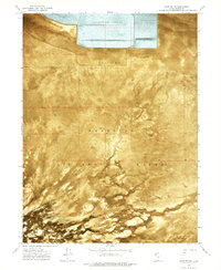
1973 Map of Salduro SW
USGS Topo · Published 1977About this map
The Wendover Air Force Range occupies a significant portion of this Great Salt Lake Desert landscape, reflecting the military's long-standing footprint in this corner of Tooele County. Captured through 1972 orthophotography and 1973 ground surveys, the map reveals a stark environment defined by expansive deposits of Alkali or Mud that stretch across the salt flats. To the north, a complex of Evaporator Ponds highlights the industrial mineral extraction efforts characteristic of the region's economy.
Find a feature on this map
5 named features on this map. Tap any name to fly to it.
Don’t see what you’re looking for? This feature index may not catch every label — zoom into the map to look around manually.
Map Details
Editions of this 1973 Salduro SW Map
This is the sole edition of this map. No revisions or reprints were ever made.
Other maps of this area

1953 · Tooele
USGS Topo · 1:250,000

1955 · Tooele
USGS Topo · 1:250,000

1955 · Elko
USGS Topo · 1:250,000

1958 · Elko
USGS Topo · 1:250,000

1962 · Elko
USGS Topo · 1:250,000

1965 · Elko
USGS Topo · 1:250,000

1972 · Ferguson Flat
USGS Topo · 1:24,000
1972 · Wendover
USGS Topo · 1:24,000
1972 · Wendover SE
USGS Topo · 1:24,000
1972 · Elephant Knoll NW
USGS Topo · 1:24,000