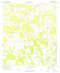
1974 Map of Sale City
USGS Topo · Published 1976About this map
Sale City anchors the southeastern corner of this Mitchell County landscape, where the Georgia Northern railroad cuts a diagonal line toward the small settlement of Greenough. The map documents a rural agricultural region defined by its watercourses and limestone topography, most notably the Oaky Sinks and the meandering path of Lost Creek as it flows toward the Ochlockonee River. This mid-1970s survey reveals a community deeply rooted in its local institutions, evidenced by the numerous country churches like Noahs Ark Ch, Zion Hill Ch, and Jerusalem Ch that dot the crossroads.
Find a feature on this map
24 named features on this map. Tap any name to fly to it.
Don’t see what you’re looking for? This feature index may not catch every label — zoom into the map to look around manually.
Map Details
Editions of this 1974 Sale City Map
This is the sole edition of this map. No revisions or reprints were ever made.
Other maps of this area

1953 · Dothan
USGS Topo · 1:250,000

1953 · Waycross
USGS Topo · 1:250,000

1954 · Dothan
USGS Topo · 1:250,000

1955 · Dothan
USGS Topo · 1:250,000

1956 · Baconton
USGS Topo · 1:62,500

1956 · Doerun
USGS Topo · 1:62,500

1958 · Waycross
USGS Topo · 1:250,000

1971 · Camilla
USGS Topo · 1:24,000

1971 · Cotton
USGS Topo · 1:24,000
1974 · Putney
USGS Topo · 1:24,000